

Significant Increase in Exploration Target at Kharmagtai
/EIN News/ -- TORONTO, Nov. 08, 2019 (GLOBE NEWSWIRE) -- Xanadu Mines Ltd (ASX: XAM, TSX: XAM) (“Xanadu” or “the Company”) is pleased to announce it has upgraded the global copper and gold Exploration Target at its flagship Kharmagtai project, which is located in the south Gobi region of Mongolia (Figures 1 and 2). A new global Exploration Target has been developed to highlight the large-scale copper-gold potential of the Kharmagtai project. Additionally, an independent valuation (VALMIN) has been completed by SRK for the Kharmagtai Mining Lease (please see Appendix 1).
HIGHLIGHTS
-
Large-scale global copper-gold exploration target upgraded for Kharmagtai Project above and beyond 2018 Mineral Resource Estimate
-
The Exploration Target is based on 190 diamond drill and 73 reverse circulation drill holes completed since 2002 at Kharmagtai at five separate porphyry centres with over 77,808 metres of new diamond drilling completed by Xanadu
-
Additional sulphide metallurgical work in final stages of completion
-
Compelling vectors to a very large-scale system below the surface deposits uncovered
-
Further drilling is planned to:
- Convert mineralisation within the Exploration Target into resources;
- Extend current high-grade mineralisation; and
- Test seven targets outside of the Exploration Target
- Independent Valuation for the Kharmagtai Project completed
Xanadu’s Managing Director & Chief Executive Officer, Dr Andrew Stewart, said “We have always had a strong belief in the large-scale copper-gold potential of Kharmagtai. This Global Exploration Target outlines the areas we are aiming to convert to resources in the near to mid-term. Additionally, our geologists have highlighted a series of compelling geochemical and geophysical vectors which suggest mineralisaiton within this Exploration Target is just the tip of a much larger porphyry system. We know these systems exist in Mongolia as the giant Oyu Tolgoi is currently being mined some 120km to the south of Kharmagtai and we believe that Kharmagtai is a similar type of system. Additionally, we are in the final stages of completing metallurgical work for the three existing sulphide deposits, which is aimed at increasing the already good recovery assumptions made in the 2018 mineral resource upgrade. Finally, an independent valuation of the Kharmagtai project has been completed by independent consultants, SRK. We commissioned this valuation to highlight to the market the disparity between the company’s current perceived value and the Kharmagtai project’s potential value.
Our long running objective is to develop Mongolia’s next large-scale copper gold deposit. Our current strategy of seeking high-return options via an oxide gold project is focused on providing the capital needed to advance that larger scale copper and gold project”.
GLOBAL COPPER-GOLD EXPLORATION TARGET FOR KHARMAGTAI
An exploration target has been developed for the Kharmagtai lease with the aim of highlighting the large-scale copper-gold potential of the project. The recently released Mineral Resource Upgrade and Scoping Study (please see ASX releases dated 31 October 2018 and 11 April 2019) have demonstrated a robust and viable copper-gold project, but this work only included a small portion of the known mineralisation at Kharmagtai. This Exploration Target has been developed to demonstrate the upside potential of the Kharmagtai Mining Lease and show the areas which could potentially be added to the resource inventory in the near to mid-term.
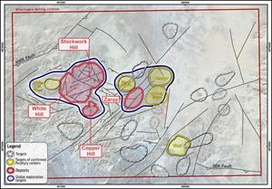
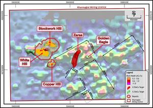
Five targets have been reviewed across the lease ranging from extensions to existing resources at Stockwork Hill, White Hill and Copper Hill to the recently discovered Zaraa and Golden Eagle deposits.
The Exploration Target is conceptual in nature as there has been insufficient exploration to define a Mineral Resource. It is uncertain if further exploration will result in the determination of a Mineral Resource under the “Australasian Code for Reporting of Exploration Results, Mineral Resources and Ore Reserves, the JORC Code” (JORC 2004). The Exploration Target is not being reported as part of any Mineral Resource or Ore Reserve and the areas of mineralisation that have been reported in the 2018 Mineral Resource Upgrade have been removed from the exploration target area.
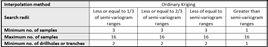
Additionally, two styles of exploration target have been defined. Table 1 shows the exploration targets as a range define based on drill results and extensions of the 2018 Mineral Resource Upgrade only.
Table 2 shows exploration targets as a range where corroborating geophysical and geological data at Zaraa highlight potential extensions to that target.
Table 1: Kharmagtai copper-gold exploration targets – drill result and block model extension data only
| Target Name | Length*1 (m) | Width*2 (m) |
Height*3 (m) | Density*4 (t/m3) |
Tonnage Range*4 | Grade Range*6 (eCu) |
Comments |
| White Hill | 1200 to 1800 | 400 to 500 | 250 to 500 | 2.76 | 331Mt to 1.24Bt | 0.3% to 0.5% eCu | See Figure 3 for dimension details |
| Stockwork Hill | 800 to 900 | 200 to 400 | 150 to 250 | 2.76 | 66Mt to 248Mt | 0.3% to 0.5% eCu | See Figure 4 for dimension details |
| Copper Hill | 200 to 300 | 100 to 200 | 200 to 300 | 2.76 | 11 to 50Mt | 0.3% to 0.5% eCu | See Figure 5 for dimension details |
| Golden Eagle | 300 to 350 | 200 to 250 | 200 to 250m | 2.76 | 33 to 60Mt | 0.3% to 0.5% eCu | See Figure 8 for dimension details |
| Target Name | Length*1 (m) | Width*2 (m) |
Height*3 (m) | Density*4 (t/m3) |
Tonnage Range*4 | Grade Range*6 (eCu) |
Comments |
| Stockwork Hill | 300-450 | 150-200 | 150-250 | 2.78 | 19Mt - 63Mt | 0.5% to 1% eCu | See Figure 4 for dimension details |
| Zaraa | 600-700 | 100-150 | 200-250 | 2.78 | 33Mt - 73Mt | 0.5% to 1% eCu | See Figure 6 for dimension details |
1* - Length of the exploration target is defined as a conservative maximum and minimum length estimation based off the distances over which drill intercepts are observed
2* - Width of the exploration targets is defined as a conservative maximum and minimum width estimation based off the distances over which drill intercepts are observed
3* - Height information is defined as a conservative maximum and minimum height estimation based off the distances over which drill intercepts are observed
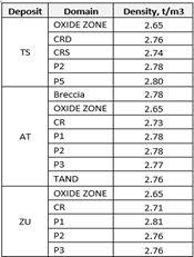
4* - Density data is taken from drilling data and assumed to be the average rock density in the Kharmagtai dataset at grade ranges above 0.3% eCu (2.76 t/m3) and 0.5% eCu (2.78 t/m3)
5* - Tonnage range is estimated as a calculation of the maximum and minimum length, width and depth multiplied by the density.
6* - Grade range is taken directly from drill results
7* - Numbers are rounded to avoid the false impression of a level of accuracy which may have led to the misrepresentation that this Exploration Target is akin to a Resource Estimation.
8* - Metallurgical recovery information is built into the eCu calculation and therefore should not be applied in addition to the tonnages reported here
9* - A floor of 600m from surface has been applied to the 0.3% eCu cut-off target to represent a realistic maximum depth for a potential open cut
10* - cut off grades of 0.3%eCu have been used to represent potential open cut material and 0.5% eCu for underground material to match that used in the 2018 MRE
Table 2: Kharmagtai copper-gold exploration target – drill result with geophysical extensions
| Target Name | Length*1 (m) | Width*2 (m) | Height*3 (m) | Density*4 (t/m3) | Bulk Tonnage Range*5 | Minus Table 1 (above) tonnage range*6 |
Geophysical Extension Tonnage Range*7 |
Grade Range*6 (eCu) |
Comments |
| Zaraa | 800 to 1300 | 150 to 200 | 500 to 600 | 2.78 | 167Mt – 434Mt | 33Mt - 73Mt | 134Mt – 361Mt | 0.5% to 1% eCu | See Figure 7 for dimension details |
1* - Length of the exploration target is defined as a conservative maximum and minimum length estimation based off the distances over which drill intercepts are observed and geological or geophysical characteristics associated with the mineralisation are observed
2* - Width of the exploration targets is defined as a conservative maximum and minimum width estimation based off the distances over which drill intercepts are observed and geological or geophysical characteristics associated with the mineralisation are observed
3* - Height information is defined as a conservative maximum and minimum height estimation based off the distances over which drill intercepts are observed and geological or geophysical characteristics associated with the mineralisation are observed.
4* - Density data is taken from drilling data and assumed to be the average rock density in the Kharmagtai dataset at grade ranges above 0.3 eCu (2.76 t/m3) and 0.5% eCu (2.78 t/m3)
5* - Tonnage range is estimated as a calculation of the maximum and minimum length, width and depth multiplied by the density.
6* - Grade range is taken directly from drill results and shown in Table 1
7* - The Exploration target from Table one is subtracted to give an extension to the Table one result
8* - Numbers are rounded to avoid the false impression of a level of accuracy which may have led to the misrepresentation that this Exploration Target is akin to a Resource Estimation.
9* - Metallurgical recovery information is built into the eCu calculation and therefore should not be applied in addition to the tonnages reported here
10* - cut off grades of 0.3% eCu have been used to represent potential open cut material and 0.5% eCu for underground material to match that used in the 2018 MRE
ABOUT WHITE HILL
White Hill represents the largest outcropping body of mineralisaiton at Kharmagtai. Mineralisaiton consists of disseminated copper sulphides associated with high-density quartz veining typical of a large porphyry system. The dimensions for the Exploration Target at White Hill are based off diamond drill holes with drill results over 0.3% eCu (Figure 3). Geological and structural analysis of the White Hill deposit over the past year has shown that the higher-grade mineralisaiton is associated with a combination of a dyke of monzodiorite (P2) and series of west-northwest dipping faults. It is believed these faults have helped channel mineralisaiton upwards where it has interacted with magnetite bearing quartz stockworks in and around the monzodiorite dyke resulting in the precipitation of copper and gold. This model significantly expands the area over which mineralisation could occur and suggests the White Hill system is significantly larger than previously thought. Geophysical data suggests that the White Hill deposit will join at depth with the Stockwork Hill Deposit.
ABOUT STOCKWORK HILL
Stockwork Hill is the second largest zone of outcropping mineralisaiton at Kharmagtai. Mineralisaiton consists of a combination of high-grade stockworks and tourmaline breccias. Recently, the high-grade extensions to the deposit were discovered when an offset zone of gold-rich bornite mineralisaiton was drilled south of the main tourmaline breccia body. This work has shown that Stockwork Hill is linked at depth to a potentially much larger and higher grade bornite zone. Due to the variation in the style of mineralisation the geophysical signature of the deposit is not fully understood. The high-density stockwork zones respond in magnetics surveys but the tourmaline breccia appears to be magnetically destructive. Induced polarisation appears not to see the mineralisaiton as the sulphides are massive breccia infill and vein hosted rather than disseminated. The Exploration Target at Stockwork Hill was therefore only based on diamond drill results only (Figure 4). There is a strong magnetic anomaly that sits below Stockwork Hill to the southwest, suggesting the potential for a large high-density stockwork zone that may also link to White Hill.
ABOUT COPPER HILL
Copper Hill is the highest-grade zone of mineralisation at Kharmagtai and was discovered when a small but intense magnetic high was drilled early in Kharmagtai’s history. Mineralisation consists of very high-grade chalcopyrite veins overprinting an existing stockwork of quartz magnetite veins. In a scenario very similar to White Hill, mineralisaiton is associated with the confluence of a P2 monzodiorite dyke and west-northwest dipping faults (Figure 5). Beneath Copper Hill sits a large zone of high intensity magnetics which may represent the extensions to Copper Hill.
ABOUT ZARAA
Zaraa was discovered in 2018 as a part of the undercover initiative. Mineralisation at Zaraa consists of chalcopyrite bearing quartz veins and chalcopyrite only veining associated with a series of P2 monzodiorite dykes. The Zaraa system has a very large 3DIP chargeability anomaly which sits above and surrounding the mineralisation (Figure 6). Due to the size of Zaraa and the limited amount of drilling a conservative approach has been taken to developing an Exploration Target with only drilling data having been used. However, should the zone of known mineralisation be extended using geophysical corroboration seen in the IP data a significantly larger Exploration Target would be appropriate (see Table 2 and Figure 7).
ABOUT GOLDEN EAGLE
Golden Eagle was discovered in 2017 as a part of the undercover initiative. Mineralisaiton at Golden Eagle consists of chalcopyrite bearing quartz-magnetite veins and disseminated chalcopyrite with free gold. Mineralisation at Golden Eagle broadly coincides with a large magnetic high relating to the magnetite content of the porphyry quartz veining. The Exploration Target at Golden Eagle has been based solely on drilling data (Figure 8).
LARGE SCALE POTENTIAL OF THE KHARMAGTAI LEASE
The undercover initiative implemented in 2016 is still being followed up upon. There are large parts of the Kharmagtai Mining Lease which exhibit significant copper and gold geochemical anomalism (Figure 9) that require follow up drilling to test. The shallow open pit potential of the lease is still significant. Additionally, porphyry mineral systems form as copper and gold are concentrated through a series of vertically staged magma chambers. It is this characteristic that makes these systems so large. At Oyu Tolgoi, 120km south of Kharmagtai the main mineral deposit does not start until >600m vertically from surface and extends to some 2400m below surface to where drilling stopped.
At Kharmagtai there are a set of compelling vectors that suggest the mineralisation seen at surface is just the top of a much larger system. The first of these vectors is the gravity data. When the low frequency gravity data is reviewed a very large, higher density body is seen below the surface mineralisaiton (Figure 10). This body could represent another, larger staging chamber, from which the currently drilled mineralisation may have evacuated. Another compelling feature are the zones of high magnetics below Stockwork Hill, White Hill and Copper Hill. These may represent zones of high-density quartz-magnetite-chalcopyrite-bornite veining (Figures 11, 12 and 13). Additionally, porphyry systems are usually zoned chemically. Molybdenum often forms a halo above and around the tops of copper gold porphyry systems. At Kharmagtai this zonation is seen, most clearly at White Hill, however, another halo of molybdenum enrichment can be cross cutting the base of White Hill and Zaraa, strongly suggesting a larger copper gold system lies beneath the surface mineralisaiton (Figure 14). When combined, these vectors paint the picture of a giant porphyry system below the existing mineralisation.
PROGRAM REQUIRED TO CONVERT EXPLORATION TARGETS TO RESOURCES AND DISCOVER LARGE-SCALE POTENTIAL
A geophysical and drill program has been designed and costed to convert the above Exploration Targets into inferred Mineral Resources and discover the hypothesised very large-scale copper gold porphyry system beneath the existing resources.
The first phase of exploration would consist of a tenement wide seismic survey conducted in parallel with a similar spaced deep seeing magnetotellurics (MT) program. Seismic would be used to define the fault architecture of the entire mining lease to ensure the drill targeting is as accurate as possible. A magnetotellurics program would be conducted to identify large zones of sulphide mineralisation located beneath the structures highlighted by the seismic survey. This program has been costed at between $300 to $600K depending on the geophysical contractor used and would form the basis of the drill targeting for the Oyu Tolgoi sized system at Kharmagtai.
Drill holes have been planned for Stockwork Hill, Copper Hill, Zaraa and elsewhere within the tenement to convert the above exploration target into an inferred mineral resources. Costing for this program is summarised in Table 3 below).
INDEDENDENT VALUATION OF THE KHARMAGTAI PROJECT BY SRK CONSULTING
An independent valuation of the Kharmagtai Property has been conducted by SRK Consulting (Australasia) Pty Ltd) (SRK) in accordance to the VALMIN Code (2015). The objective of SRK’s report was to demonstrate the difference between the current company market valuation and a conservative and independent expert valuation of one of the projects within Xanadu’s portfolio. This valuation can be found in Appendix 1.
Table 3: Indicative drill costs
| Target | Target Type | Target Res Cat | # Drill Holes | DDH (m) | RC (m) | Assays | Total Cost | ||
| Copper Hill | Open Pit/UG | Indicated | 13 | 13000 | $ | 6,500 | $ | 2,184,040 | |
| Stockwork Hill Bornite | Underground | Indicated | 25 | 35000 | $ | 15,000 | $ | 5,840,040 | |
| White Hill West | Open Pit/UG | Indicated | 48 | 0 | 13000 | $ | 7,500 | $ | 1,095,040 |
| Zaraa | Underground | Inferred | 20 | 22862 | $ | 11,000 | $ | 3,833,960 | |
| Porphyry Cluster One | Open Pit/UG | Discover | 18 | 2600 | 2600 | $ | 2,600 | $ | 652,640 |
| Porphyry Cluster Two | Open Pit/UG | Discover | 28 | 4200 | 4200 | $ | 4,200 | $ | 1,054,240 |
| Porphyry Cluster Three | Open Pit/UG | Discover | 17 | 2650 | 2650 | $ | 2,650 | $ | 665,190 |
| Porphyry Cluster Four | Open Pit/UG | Discover | 8 | 1200 | 1200 | $ | 1,200 | $ | 301,240 |
| Porphyry Cluster Five | Open Pit/UG | Discover | 17 | 2550 | 2550 | $ | 2,550 | $ | 640,090 |
| Porphyry Cluster Six | Open Pit/UG | Discover | 12 | 1800 | 1800 | $ | 1,800 | $ | 451,840 |
| Large scale Cu-Au system | Underground | Discover | 20 | 36000 | $ | 18,000 | $ | 6,048,040 | |
| Total | $ | 22,766,360 | |||||||
Photos accompanying this announcement are available at:
https://www.globenewswire.com/NewsRoom/AttachmentNg/d54dc012-f314-4346-b393-e498eb33506e
https://www.globenewswire.com/NewsRoom/AttachmentNg/681cf61a-e1f8-4c3b-b940-8437db4f00f5
https://www.globenewswire.com/NewsRoom/AttachmentNg/e5134b81-c22b-44d1-8909-62e6d54bec02
https://www.globenewswire.com/NewsRoom/AttachmentNg/8a07cbd9-afda-4726-9518-594a0ac21f38
https://www.globenewswire.com/NewsRoom/AttachmentNg/e9ad1e76-a208-4d1c-8cf5-74073f598417
https://www.globenewswire.com/NewsRoom/AttachmentNg/078f6e1a-5c56-4f8e-b0be-2e2211941315
https://www.globenewswire.com/NewsRoom/AttachmentNg/ec1017c7-65fd-4ea1-950b-65e1b1497127
https://www.globenewswire.com/NewsRoom/AttachmentNg/590c39d7-0ac8-404f-8213-e85a2b421f01
https://www.globenewswire.com/NewsRoom/AttachmentNg/f67f0d29-e880-4b23-9ca1-020a81015eed
https://www.globenewswire.com/NewsRoom/AttachmentNg/e06fc43f-07b5-4ee1-80fa-745cda6db6d3
https://www.globenewswire.com/NewsRoom/AttachmentNg/2fe6a9ce-4bce-4f35-8b22-2b00b43c09f2
https://www.globenewswire.com/NewsRoom/AttachmentNg/8917a189-f9e6-4e34-b225-4eb110116a1d
https://www.globenewswire.com/NewsRoom/AttachmentNg/f77ea4ce-f078-492f-9b4d-410f76a20279
https://www.globenewswire.com/NewsRoom/AttachmentNg/f320c1e6-297f-478c-af2a-b2c621c52565
COMPETENT-QUALIFIED PERSON STATEMENT
The information in this announcement that relates to exploration results is based on information compiled by Dr Andrew Stewart who is responsible for the exploration data, comments on exploration target sizes, QA/QC and geological interpretation and information. Dr Stewart, who is an employee of Xanadu and is a Member of the Australasian Institute of Geoscientists, has sufficient experience relevant to the style of mineralisation and type of deposit under consideration and to the activity he is undertaking to qualify as the “Competent Person” as defined in the 2012 Edition of the “Australasian Code for Reporting Exploration Results, Mineral Resources and Ore Reserves” and the National Instrument 43-101. Dr Stewart consents to the inclusion in the report of the matters based on this information in the form and context in which it appears.
COPPER EQUIVALENT CALCULATIONS
The copper equivalent (eCu) calculation represents the total metal value for each metal, multiplied by the conversion factor, summed and expressed in equivalent copper percentage with a metallurgical recovery factor applied. The copper equivalent calculation used is based off the eCu calculation defined by CSA in the 2018 Mineral Resource Upgrade.
Copper equivalent (eCu) grade values were calculated using the following formula:
eCu = Cu + Au * 0.62097 * 0.8235,
Where:
| • | Cu | - | copper grade (%) |
| • | Au | - | gold grade (g/t) |
| • | 0.62097 | - | conversion factor (gold to copper) |
| • | 0.8235 | - | relative recovery of gold to copper (82.35%). |
The copper equivalent formula was based on the following parameters (prices are in USD):
| • | Copper price | - | 3.1 $/lb (or 6834 $/t) |
| • | Gold price | - | 1320 $/oz |
| • | Copper recovery | - | 85% |
| • | Gold recovery | - | 70% |
| Relative recovery of gold to copper = 70% / 85% = 82.35%. | |||
CAUTIONARY STATEMENTS REGARDING EXPLORATION TARGETS
The Exploration Target is conceptual in nature as there has been insufficient exploration to define a Mineral Resource. It is uncertain if further exploration will result in the determination of a Mineral Resource under the “Australasian Code for Reporting of Exploration Results, Mineral Resources and Ore Reserves, the JORC Code” (JORC 2004). The Exploration Target is not being reported as part of any Mineral Resource or Ore Reserve and previously reported areas of Mineral Resource have been extracted from the Exploration Target.
For further information, please contact:
Andrew Stewart
Chief Executive Officer
T: +61 2 8280 7497
M: +61 409 819 922
Andrew.stewart@xanadumines.com
www.xanadumines.com
APPENDIX 1: INDEPENDENT VALUATION (VALMIN 2015) OF THE KHARMAGTAI PROPERTY
http://ml.globenewswire.com/Resource/Download/2a3c0f2a-a5bb-4eaf-bb47-b741b2f03d88
APPENDIX 2: KHARMAGTAI TABLE 1 (JORC 2012)
1.1 JORC TABLE 1 – SECTION 4 ESTIMATION AND REPORTING OF ORE RESERVES
Set out below is Section 1 and Section 2 of Table 1 under the JORC Code, 2012 Edition for the Kharmagtai project. Data provided by Xanadu. This Table 1 updates the JORC Table 1 disclosure dated 31 July 2018.
1.2 JORC TABLE 1 - SECTION 1 - SAMPLING TECHNIQUES AND DATA
| Criteria | JORC Code explanation | Commentary |
| Sampling techniques |
|
|
| Drilling techniques |
|
|
| Drill sample recovery |
|
|
| Logging |
|
|
| Sub-sampling techniques and sample preparation |
|
|
| Quality of assay data and laboratory tests |
|
|
| Verification of sampling and assaying |
|
|
| Location of data points |
|
|
| Data spacing and distribution |
|
|
| Orientation of data in relation to geological structure |
|
|
| Sample security |
|
|
| Audits or reviews |
|
|
1.3 JORC TABLE 1 - SECTION 2 - REPORTING OF EXPLORATION RESULTS
| Criteria | JORC Code explanation | Commentary | ||||||||
| Mineral tenement and land tenure status |
|
|
||||||||
| Exploration done by other parties |
|
|
||||||||
| Geology |
|
|
||||||||
| Drill hole Information |
|
|
||||||||
| Timing | RC Holes | Metre | DDH Holes | Metre | RC & DDH | Metre | Trench | Metre | ||
| Drilling <2015 | 155 | 24553 | 252 | 88511 | 0 | 0 | 106 | 39774 | ||
| Drilling >2015 | 68 | 13107 | 116 | 57876 | 22 | 5323 | 17 | 5618 | ||
| Total | 223 | 37660 | 368 | 146387 | 22 | 5323 | 123 | 45392 | ||
| ||||||||||
|
||||||||||
| Data aggregation methods |
|
|
||||||||
| Relationship between mineralisation widths and intercept lengths |
|
|
||||||||
|
|
|||||||||
|
||||||||||
| Diagrams |
|
|
||||||||
| Balanced reporting |
|
|
||||||||
| Other substantive exploration data |
|
|
||||||||
| Further work |
|
|
||||||||
1.4 JORC TABLE 1 – SECTION 3 ESTIMATION AND REPORTING OF MINERAL RESOURCES
| Criteria | JORC Code explanation | Commentary | |
| Database integrity |
|
|
|
| Site visits |
|
|
|
| Geological interpretation |
|
|
|
| Dimensions |
|
|
|
| Estimation and modelling techniques |
|
|
|
| Moisture |
|
|
|
| Cut-off parameters |
|
|
|
| Mining factors or assumptions |
|
|
|
| Metallurgical factors or assumptions |
|
|
|
| Environmental factors or assumptions |
|
|
|
| Bulk density |
|
|
|
| Classification |
|
|
|
| Audits or reviews |
|
|
|
| Discussion of relative accuracy/ confidence |
|
|
|
1.5 JORC TABLE 1 – SECTION 4 ESTIMATION AND REPORTING OF ORE RESERVES
Ore Reserves are not reported so this is not applicable to this report.
![]()
FIGURE 1:
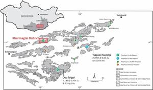
Location of the Kharmagtai Project in the South Gobi porphyry copper belt.
FIGURE 2:
The Kharmagtai Mining Licence showing location of the Kharmagtai Deposits (Stockwork Hill, White Hill, Copper Hill) and areas covered within the Global Exploration Target.
FIGURE 3:
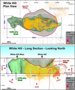
Plan and long section of White Hill showing drilling, 2018 Mineral Resource Upgrade ultimate pit and block model outside what has been reported. Dimensions showing the exploration target for 0.3%eCu, Table one only uses a 500m height dimension (rather than the depicted 600m) to compensate for and remove the mineralisation reported within the current 2018 MRE.
FIGURE 4:
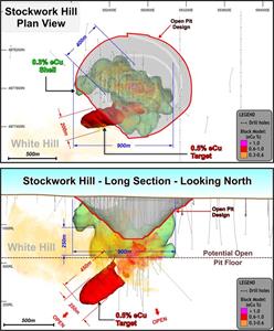
Long Section of Stockwork Hill showing 2018 Mineral Resource Upgrade ultimate pit and block model outside what was reported in the 2018 MRE. Dimensions showing the exploration target for 0.3%eCu and 0.5%eCu are shown with a floor at 600m to symbolise the potential depth of an open pit.
FIGURE 5:
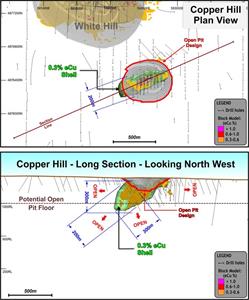
Plan and long section of Copper Hill showing 2018 Mineral Resource Upgrade ultimate pit and block model outside what was reported in the 2018 MRE. Dimensions showing the exploration target for 0.3%eCu are shown with a floor at 300m to symbolise the potential depth of an open pit. There is significant potential for repeated high-grade zones at depth down plunge of Copper HiIl and drilling for this is included in the exploration plan.
FIGURE 6:
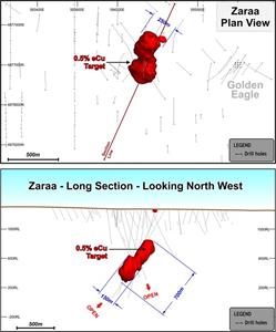
Plan and long section of Zaraa showing drilling and dimensions of Exploration Target.
FIGURE 7:
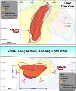
Plan and section of Zaraa showing extended Exploration Target based off drilling and geophysics
FIGURE 8:
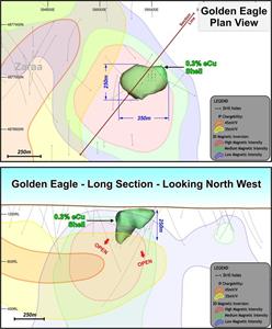
Plan and long section of Golden Eagle showing drilling, exploration target, inverted 3DIP and VRMI data and 0.3eCu boundary based off drilling.
FIGURE 9:
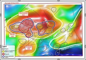
Geochemical anomalism (eCu) across the Kharmagtai Lease. The undercover initiative geochemistry program initiated in 2016 is still being followed up on. There remains a significant surface area of geochemical anomalism that required additional exploration for shallower resources within the Kharmagtai Lease.
FIGURE 10:
Bougier gravity anomaly beneath Kharmagtai is suggestive of a very large staging chamber beneath the known mineralisaiton
FIGURE 11:
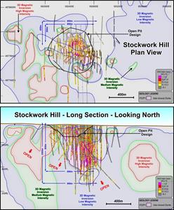
Plan and long section through Stockwork Hill showing high magnetic zones which may represent repeated zones of untested stockwork mineralisation.
FIGURE 12:
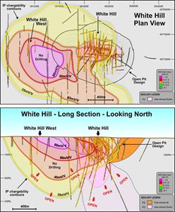
Plan and long section through White Hill showing large IP anomaly associated with the western extensions to the deposit. IP anomalies normally form above the zones of higher-grade mineralisation within porphyry deposits suggesting potential significant extensions to White Hill.
FIGURE 13:
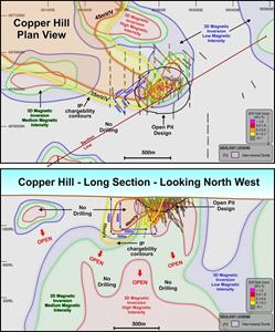
Plan and long section of Copper Hill showing deep high magnetic bodies which may represent repeat zones of high-density stock working below the main deposit. An IP chargeable high lies directly above this zone.
FIGURE 14:
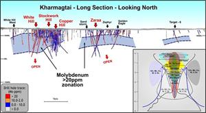
The molybdenum geochemistry across the lease highlights a second system, a large copper gold system stacked beneath the existing deposits. At Stockwork Hill the molybdenum signature has been destroyed by the overprinting tourmaline breccia. Elsewhere it is well preserved across the entire lease.
1.4 JORC TABLE 1 – SECTION 3 ESTIMATION AND REPORTING OF MINERAL RESOURCES
Estimation and modelling techniques
1.4 JORC TABLE 1 – SECTION 3 ESTIMATION AND REPORTING OF MINERAL RESOURCES
Bulk density
EIN Presswire does not exercise editorial control over third-party content provided, uploaded, published, or distributed by users of EIN Presswire. We are a distributor, not a publisher, of 3rd party content. Such content may contain the views, opinions, statements, offers, and other material of the respective users, suppliers, participants, or authors.